Mt Lodge, Paparoa National Park - Image - Zak Shaw
Inland past the popular tourist stopover of Punakaiki's pancake rocks lies the buckled Paparoa Range. The granite and gneiss rocks of the range are some of the countries oldest forming a seemingly impenetrable band of craggy peaks. Beech forest, alpine flora and tussock blankets the slopes of the range and is frequently cloaked by lingering cloud. On average 8000 millimetres of rain falls annually. Towering bluffs, abrasive scrub faces and deeply gouged cirques are the cause of hesitation for the roaming tramper.

Alpine ridge travel - Image - Zak Shaw
Few formed routes exist in this part of the country. Those that exist do so on the park's relative periphery. An adventure into the interior proper requires determination, sound navigational skills, a goat like climbing ability and the confidence to make your own tracks.
During our five day visit we would attempt a traverse of the ranges southern extent. The distance would stretch to around 45km starting near the settlement of Barrytown and finishing at the Bullock Creek road end and the Cave creek submergence.
As part of the Taipotini Polytechnic Leadership and Guiding certificate program I was employed with tutor Keith Riley to educate students in the bush/alpine environment and manage the overall safety of the adventure. The Taipotini students planned the week down to every ration and caloric intake. Chunky pound of butter size energy bricks were dispersed along with precisely measured bags of meals, cookers, pots, tents and maps.

Image - Zak Shaw
The route from sea level near Barrytown climbed 1100m before the tracks burst clear of the bush-line.
Our first contact with snow came with light flakes falling a mere 300m above sea level. Unfazed and confident in the forecasted weather report we continued on over the summit of Mt Ryall and made a left turn onto the Paparoa Range. That evening we camped as night set in below an unnamed trig station. The temperature plummeted when the sun dipped below the ocean and dinner was cooked at a temperature of minus eight degrees.

Day two sunshine and pleasant tussock travel - Image - Zak Shaw
After a brutally cold start things warmed up during our second day. The open beech forest leading to the gradual rollover of Mt Anderson was highly stimulating terrain as the forest floor came to life. An undisturbed canopy sat quiet with shards of light illuminating the supernatural.

Imaginary scenes - Image - Zak Shaw

Image - Zak Shaw
We skirted an escarpment that climbed above the Punakaiki River. Sections of our route dropped away several hundred metres to the valley.

Image - Zak Shaw

Mountain Nei Nei or Dracophyllum - Image - Zak Shaw

Image - Zak Shaw
Open ridge-line travel in dispersed with mature open forest lead our team over the summits of 'Mt Hawera', the 'White Night' and 'Mt Pecksniff' A chilly southerly wind stripped our heat away at every pause in travel. Movement on the lee of the ridge often meant sun, no wind but scrub fighting travel. On the windward side shaded aspects were markedly cooler but flowed well with long uninterrupted sections of clear forest. Travel speeds averaged 1km/hr.

After another eight hour day camp three was chosen in haste. From high on the ridge we descended into a creek as the sun set magnificently over the Tasman sea. Despite first impressions with a little work we jammed six tents onto every square cm of useable ground. Although brutally cold it turned out to be one of our best nights sleep.


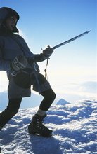
Climbing on positive holds. Image - Zak Shaw
From between 1240m and 1210m spot heights a freezing wind funneled into our camp. We packed as quickly as possible before climbing back to the ridge. The most demanding terrain came at us on day four. Negotiating sections of exposed rock and steep razorback aretes required long spells of concentration and route finding. By 3pm we had climbed under a steep headwall and rounded over a south facing snow covered pass. At 4 we dropped into a sunny camp with fantastic views of Mt Lodge and the extremely rugged massifs of the northern Paparoa's.

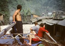
Keith Riley chillin out in camp 4
Image - Zak Shaw

Grace Fleming and Adrian Butler enjoy an amazing alpine sunset.
Image - Zak Shaw

Mt Lodge - Paparoa National Park
Image - Zak Shaw
At 6.30am our final day began and we hustled to break camp. The walk along the remainder of the range towards Mt Bovis began at 8am with another clear sunny day in store. Some of the most consequential sections of travel confronted us in this final leg. Steep terrain required sure footing and patience. Nine hours later we dropped out of the bush arriving at the Bullock Creek car park.

Taipotini Polytechnic students at the col between 1236m and 1216m