To gain some perspective of what its like to stand beside the East Waikaia River one needs to consider this.
A relentless barrage of whitewater flowing through alpine tussock highlands. A medieval landscape of craggy backcountry and subtle contours. A world colored honey and blue. An archaic scene, a place seldom travelled, horses, carts, spaniard grass and the constant roar of water....
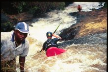
When the attack came it did so for three days. Stonking class five, so damn good!
Those who kayak will appreciate some comparison between rivers. To understand the unrelenting nature of the East Waikaia multiply the Nevis Rivers length by four and its gradient by two. The stats pour onto the paper something like this.
Put in elevation - 1000m, Drop in elevation - 600m, Length - 16km.
For the bulk of the run it drops at an average of 60-80m/km with around 10 cumecs at the put - in and around 18cumecs at the East/ West Waikaia rivers confluence.
Local Southland boy and trip mastermind Keith Reiley confirms the plan.
Image - Zak Shaw

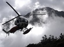
Andrew Gunn based in Waikaia jumped at the chance to help us out with access. It didn't take long for the landowners to be contacted and for permission to be gained. On the day Andrew from High Country Helicopters showed up in his number ones poised and ready to get the job done.

Image - Zak Shaw

Once loaded our flight began with immediate interest. Lots of whitewater, lots of drops. It never let up. Eddies were few. The lower river lay hidden under a canopy of Beech forest but as we climbed further tussock blanketed the hills exposing the river and what lay in store.
Keith and Dylan Thompson couldn't beleive their eyes. From my seat I gained rare views of the river below. Expressions on Keith's face were my only source of information. Like an excited child wriggling in his seat the windows were not big enough! Serious, raised eyebrows, stern, yes, yes, holy shit, ok, maybe, hell yeah, thats big, not sure, thats bigger, 50/50, yes, golden. I'm in!
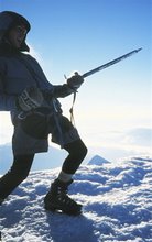
Keith Reiley on route.
Image - Zak Shaw
Our team for the day stretched to three. (Andrew flies in three loads)
Keith, Dillon Thompson and myself.

Image credit - Keith Reiley.
Dylan Thompson arrived on the back of Keith's encouraging phone call the night before.
"You want to be here Dillon" "Whatever plans you have Dylan" I understand that Dylon but"
"I'll apologise to your girlfriend for ya mate"
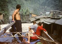
Dylon drove three hours to meet us above the Canton Bridge and the day began.

Dylan and Keith at the rivers put in. The Waikaia catchment is also home to many historical sites including stone huts, cave dwellings, wooden barrels, pots and dirt sleeping pads.
Image - Zak Shaw

Things kicked off easy with five hundred metres of class two before all hell broke loose.
The environment was unlike anywhere I'd been before. Golden tussock, primeval stone pillars and big blue skies.
Image - Zak Shaw

Dylon stamped our mark early. A paddler who sees a line and whats possible in kayaking more often than most. This came apparent as hard moves and intricate lines with high objective danger came thick and fast. Image above Dylan keeps the nose up half way through a long (they are all long) hard and steep rapid early on.
Image - Zak Shaw

Our pace downriver was slow. The common thread with each rapid was "what's downstream of this" because sure enough around the next bend lay the next thing to catch our attention.
Stacked one after the other we found respite in small one boat eddies. Scouting required 200-300m long distances often from both sides in order to get the right information.
Image above Keith links it all together, staying composed and focused.
Image - Zak Shaw

The Southland high country. Mid way through day one things went into another gear. We were all paddling at the top of our game and deliberated for over an hour above a 400m section of relentless carnage. Limited eddies were the deciding factor and we opted for the "smart" decision to move overland. Time = 4pm. On day one we pushed through until 6pm. The whitewater had just begun to change character slightly. Landing in an eddy Keith's paddle suffered a crack in one blade. Rather than push on with our breakdown paddles we glanced over the map and came to the relisation that we had travelled downstream to within 500m of an established farm track that would lead us out to the van. We had always planned on hiking out with the days remaining daylight and so if you can call breaking a paddle good, it came at the right time. The hike back to the van took two hours on a 4wd road.
Image above - Zak Shaw

Day two we portaged a short section because of a tree jam. Rounding the next corner the intensity of day one came looking for us again. The scout for the following 200m of whitewater accounted for two hours of our day as we had to move up and down the bank to provide safety for each other. We all emerged unscathed from the bottom of this drop which was the accululation of several must make moves. In the above image Dylan Thompson probes and boosts confidence in Keith and myself.

Image above - Keith Reiley is online. After this drop we paused for a short lunch break.
Glancing back upriver the gradient of our previous drops run was remarkable. "Look at that, we're a loose pack of barstards aren't we" Keith Reiley...
Image - Zak Shaw

More of the same. Not to give viewers the impression we were starting to get bored. Every move required constant focus. Its been a long time since Ive paddled a river that has required such a sustained level of mental focus. The East Waiakaia is not about isolated hard moves.
Image - Zak Shaw - note we did not run the top part of the above rapid.

Image - Zak Shaw
Our intention with the East Waikaia had always been to push through in two days. Day two dragged on and on and on. After eight hours (we began kayaking at 10.30am after a two hour walk back to the river) our light in the gorge began to fade. Our energy levels began to drop off but we were sure the confluence with the West Waikaia was not far off.

Image - Zak Shaw
Dylan launches off another clean drop. This drop marked the entrance into another 300m long section. I opted to hike over the left bank and avoid making testing moves above a certain portage. Both Dylan and Keith greased the entrance drops and scampered quickly back for the last chance eddy.

Image - Zak Shaw
Stern expressions....tired...how far to go? At 8.30pm the world dropped away extinguishing our hopes of making it out before dark. We were tired and not in good enough shape to consider firing up this 30ft drop.
On the lip of the falls is a terrible sieve and none of us felt any motivation towards running it after such a draining day out. For the second time we abandoned the gear and pushed through the broom to the ridgeline. The scrub tore skin from our hands scratching us to bits and made our escape a brutal exercise.

Image - Zak Shaw.
Feeling the burn we commenced day three. Being a little smarter in our approach we made good time back via open farmland and an airstrip. Linking grass clearings our descent back to the kayaks was easy. Then came time to resume the kayaking...

Image - Zak Shaw
Keith was the bold one and paddled first. Determined in his belief that the dangerous entrance move would be relatively straight forward leading up to the main event.
Keith moved past the sieve and set sail off the drop in fine form.

Dylan Thompson poised with the crucial stroke.
Image - Zak Shaw

Image - Zak Shaw
My turn came third. Nervous about consequence I welcomed a quick check in with Keith on my way to my kayak. My line went well. I arrived with speed at the edge and landed flat in the aerated pool.

After the first move of day three we celebrated success!

Keith Reiley picks up the camera!
Paddler - Zak Shaw

Job done! Keith and Dylan roll through the East/West Waikaia River confluence.
Image - Zak Shaw

Image - Zak Shaw
Keith and Dylan both carried HD cameras and have come away with some great footage.
Looking forward to seeing that on the big screen!
Thanks for checking in - Zak

 "The Nevis River drains the Hector and Garvie mountain ranges, flowing north towards the Kawarau River. The valley is at first a wide open expanse and was the scene of prolific goldmining during the late 1800's. Many historic relics remain in the upper valley as a testament to the industry that was there" - http://www.wildrivers.org.nz/river/nevis-river
 Keith Riley, Ants Longman and myself recently spent a day in the Upper Nevis Valley. The flow below the Nevis Crossing road bridge was on deemed too high and so we continued up river. The area we visited would be inundated should the Pioneer Generation dam scheme go ahead.
 Image - Zak Shaw
 Spaniard grass and unique landscape. Nevis Valley - Image - Zak Shaw
 The Upper Nevis gorge - Image - Zak Shaw
 Paddler Keith Riley
 Paddler Antz Longman
 Paddler - Keith Riley