
Lifeblood of a Nation - please see below for the background on this project.
cheers - Zak Shaw
 Image - Cover shot! Eye candy and the heart of the Burke Rivers "Churn Gorge"
 Image - Zak Shaw
The Burke River was first descended thirteen years ago. As a three day adventure spearheaded by Keith Reiley a team discovered another stunning river trip in South Westland. Late on day two darkness fell as the paddlers arrived the "Churn Gorge" the rivers last attack. Poor light and a gorge reminiscent of the legendary Clarksfork of the Yellowstone's "Box canyon" forced an unexpected third night out.
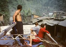
 Our day began at Haast beach.
 Image Zak Shaw
 For years both Keith and myself had planned on returning to the Churn Gorge to inspect the whitewater that Keith had managed to catch a glimpse of. Memories of teacup drops in a seriously committing canyon provided the lure and encouraged us back.
 For years both Keith and myself had planned on returning to the Churn Gorge to inspect the whitewater that Keith had managed to catch a glimpse of. Memories of teacup drops in a seriously committing canyon provided the lure and encouraged us back.
Image above - We set out by crossing the Haast River loaded with ropes, harnesses and a rough optimistic plan.
Image - Zak Shaw
 Heading upriver we paddled into the Burke Gorge from the bottom up before the gradient began. The Burke gorge is an amazing sight. Stunning water color, trout every metre and glistening side creek waterfalls.
 Heading upriver we paddled into the Burke Gorge from the bottom up before the gradient began. The Burke gorge is an amazing sight. Stunning water color, trout every metre and glistening side creek waterfalls.
Image - Zak Shaw
 The Churn Gorge!!! an amazing place to be.
 The Churn Gorge!!! an amazing place to be.
Image - Zak Shaw
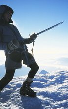
After half an hour of paddling we left the kayaks and set off with the packs. Climbing out of the gorge via a steep gully we moved quickly through open rainforest following deer trails. We managed to gain several views of the gorge below and felt good about paddling the whitewater. Once in the gorge at water level we had to be sure we could get out as the canyon walls were carved bedrock making every drop a must run.
At 2pm we returned to the kayaks having seen the whole gorge. Access would require a 60m abseil onto a slopping ledge. A 40ft cauldron style waterfall flowing directly into another big committing drop has us peering out of the bush from 100m up with high interest.
Both drops are at the very extent of what's possible in whitewater. After the second drop we lost sight of the river before it charged around a bend into a certain portage that we were 80% wasn't possible. We then headed back to the kayaks having shot some great pics, but happy to be walking away.
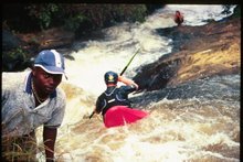
 A short abseil into the gorge below the crux Churn drops put us in place for some full on kayaking.
 Image - Keith fires off the first drop
Zak Shaw.
 5pm and about time to get wet. Inside the gorge we paddled several testing drops and everything was much harder than expected. One horizon line we paddled at blind but emerged unscathed.
 5pm and about time to get wet. Inside the gorge we paddled several testing drops and everything was much harder than expected. One horizon line we paddled at blind but emerged unscathed.
  The Burke Rivers box canyon. - Approaching from the bottom its flat-water until you get to here. Anyone with a paddle can make their way inside the Burke Gorge. I highly recommend it!
Image - Zak Shaw
 "Lifeblood of the Nation" is a SPARC funded initiative. Its focus is towards raising the profile of New Zealand's wild rivers. Rivers that all NZers can enjoy, should appreciate and are privileged to have. Check out www.wildrivers.org.nz
 "Lifeblood of the Nation" is a SPARC funded initiative. Its focus is towards raising the profile of New Zealand's wild rivers. Rivers that all NZers can enjoy, should appreciate and are privileged to have. Check out www.wildrivers.org.nz
 Image - Zak Shaw


Hi Zak
ReplyDeleteI bumped into your site trying to find where on google earth the Burke River joins the Haast. I want to do some scenic photography in the area, and wondered if you have lat and long for the joining point. Also how far from the join can one walk up the Burke River, I will not have a kayak.
Thanx
Karl